Studio711.com – Ben Martens

Video

Potholes Timelapse Video

Yesterday I posted a timelapse video where the main feature was the GPS points on the topo map. When we drove back from Potholes a few weeks ago, I focused more on the images. I taped a USB webcam to the rear view mirror and had it connected to the laptop which was running an app to capture an image every two seconds. That worked great except that there was a problem with the inverter and the laptop battery died before we even made it back over the pass.

I took the images that we were able to snag, combined them with the GPS data and created another timelapse video. It’s all done with a custom C# program so if you geeks out there have any questions, let me know. Basically it’s a WinForms app with a web browser that loads the Bing maps and then I use Win32API calls to capture an image of the app. I have another app that combines all the image files into a WMV file.

The next thing I want to try is using the little HD video camera to record the images/video and see how that works. I have a suction cup camera mount that should make it easier to mount in the car and using the video camera means that I won’t need to have the laptop running. I plan to give it another try when we drive out to the coast in a couple weeks.

The video is embedded below, but again, it works best when you view in full screen HD quality. The GPS wasn’t able to get a lock on the signal for a while so it starts out with just images and then the location data kicks in. I wasn’t intentionally trying to keep our camping spot a secret since you could just watch the images and figure out where we were.

Camp Muir Timelapse Video

I’ve been playing around with a lot of time lapse ideas lately. I took some pictures for part of the return trip from Potholes which you’ll see soon, but on the hike up to Muir, I distracted myself by thinking how I could combine all the various data I had collected into one display.

In the backpack, the GPS was taking a recording every few seconds. I was also snapping photos every once in a while. To combine the two, I wrote an app to plot out our current location on top of a topo map and show a photo that was taken at that time (if one exists.) With the GPS data, I was also able to show our rate of ascent, the current elevation, the current time, and the latitude and longitude.

I combined that all into one application, wrote each update out to a new image file and then combined the image files into a movie file. It’s embedded below or you can find it on YouTube. It’s best when viewed in HD in full screen mode.

2009 Tulip Ride

For the past few years, I have been heading out on motorcycle rides with the same group of riders. It started as a Microsoft thing but is growing to include lots of riders from the area. Last weekend’s Tulip Ride doubled our previous turnout record. Over 80 bikes joined the ride with well over 100 total people. The weather was beautiful and we had an awesome ride.

We started off at Xbox HQ and drove up I5 to Tulalip Casino. We met more riders there and attracted the attention of the Tulalip Tribal Police. They offered a police escort through town to block traffic at the intersections so our group could go through as one. It was a huge help. Thanks!

Unfortunately there weren’t many tulips in bloom yet. It had snowed up there 10 days earlier. We did find a large field of tulips and got some nice shots. That many people will overwhelm any restaurant, so Tyla and I split off from the group and had lunch at a little cafe in Anacortes. We then headed across Deception Pass and down Whidbey Island, caught the ferry over to Mukilteo, and headed home. It was a long day but we both had a blast.

Jeff, the organizer, put together a great video of the day. Look closely and you might be able to spot Tyla and I in the first two drive by shots. You can view all my photos in the photo gallery. I also posted my own video to YouTube that shows a walk down the row of bikes at Tulalip.


Tulip Ride 2009 from Tulip Ride on Vimeo.

Park-N-Move

One of the first things I purchased for my bike was a new dolly. The old platform dolly was a bit unwieldy for this shiny (and heavier) new bike. I saw the Park-N-Move at the Seattle motorcycle show and thought it would be a good fit for this bike. It’s a small, but very sturdy, cast iron dolly that sits under the center stand. I made a little video demo of how it works.

More Big Sky

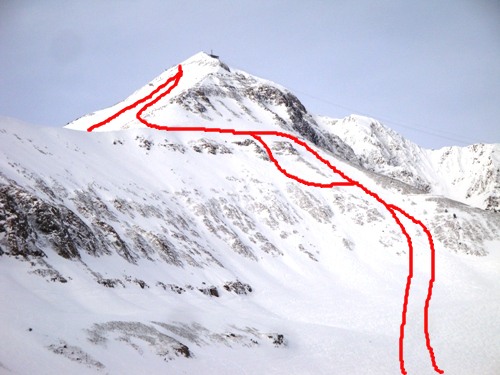
There were a few more things about Big Sky that I want to share with you. First of all, I mentioned some great lines that we took down from Lone Peak. This photo shows a couple of the runs down through the Gullies and hints at one down the side of the mountain. We had many more runs down, but I don’t have a good picture to show them.


I also made a panoramic photo from the top of the peak. It’s not quite 360 degrees, but it’s pretty close. We could see all the way down to the Grand Tetons! Click on the image for the full file (8MB) or view the nicer HDView version.

And finally, I took a bit of video on the snowmobile tour through Yellowstone. Riding one handed is a bit difficult so please pardon the shaky video. The first portion of the video is just a normal part of the ride. The last 20 seconds or so show us passing a herd of bison. While this looks very close, we actually came much closer to another herd, but I wasn’t able to get video because I was too busy trying not to die.