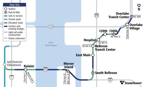
The building across the street has been taken over by WSDOT for the east side light rail extension project. It got me curious about exactly where this line will run.

In addition to the stop across the street from my building, it runs a little farther up to the Overlake Transit Center. I suspect this line will be popular with Microsoft employees since it runs right to campus.
I have mixed feelings about the project. It’s a HUGE expense (~$50 billion for the full plan) and most of that is coming out of property taxes. The proposed lines are mostly in Seattle but us east side residents will bear the brunt of the costs. The cost per rider is going to be huge compared to installations in other cities.
On the flip side, I really don’t like going into Seattle because it’s so annoying to drive and park. Buses are available but generally it takes twice as long to get where I’m going. I expect that the train will be a faster option and since the western end of this line is right by the stadiums, that could be pretty convenient.
And anyone who drives in this area knows that traffic is pretty rotten. The lake and the mountains don’t leave much room for people to travel so everyone ends up using the same roads as everyone else. With the area rapidly growing, changes need to keep coming.
Is it worth a couple hundred dollars per year in extra property taxes (and even more in other kinds of taxes)? Many of the people footing the tax bill for this will be retired or moved away from the area long before this plan is ever completed. How do you do transit planning when you can’t build fast enough to keep up with demand, costs are enormously high because of the terrain, and oh yeah, there’s not really any ROOM to put in a rail line? Sounds like a tough job. I wonder how far we could get with $50 billion if we were investigating teleportation?


Eastside Light Rail
The building across the street has been taken over by WSDOT for the east side light rail extension project. It got me curious about exactly where this line will run.
In addition to the stop across the street from my building, it runs a little farther up to the Overlake Transit Center. I suspect this line will be popular with Microsoft employees since it runs right to campus.
I have mixed feelings about the project. It’s a HUGE expense (~$50 billion for the full plan) and most of that is coming out of property taxes. The proposed lines are mostly in Seattle but us east side residents will bear the brunt of the costs. The cost per rider is going to be huge compared to installations in other cities.
On the flip side, I really don’t like going into Seattle because it’s so annoying to drive and park. Buses are available but generally it takes twice as long to get where I’m going. I expect that the train will be a faster option and since the western end of this line is right by the stadiums, that could be pretty convenient.
And anyone who drives in this area knows that traffic is pretty rotten. The lake and the mountains don’t leave much room for people to travel so everyone ends up using the same roads as everyone else. With the area rapidly growing, changes need to keep coming.
Is it worth a couple hundred dollars per year in extra property taxes (and even more in other kinds of taxes)? Many of the people footing the tax bill for this will be retired or moved away from the area long before this plan is ever completed. How do you do transit planning when you can’t build fast enough to keep up with demand, costs are enormously high because of the terrain, and oh yeah, there’s not really any ROOM to put in a rail line? Sounds like a tough job. I wonder how far we could get with $50 billion if we were investigating teleportation?