 Serverless computing is all the rage in cloud computing. When cloud computing first began, people thought about how to move their local servers to servers in the cloud. They would end up with a Windows or Linux machine hosted by Azure, etc. That was much better than operating your own data center, but technology is progressing and even managing your own machine in the cloud isn’t really necessary now. There are so many services available that simply take your code and run it for you. Don’t worry about where it’s running or what machine it’s running on. This lets you focus almost 100% of your time on the core business logic in your application and let someone else handle Windows Updates, disaster recovery, backups, etc.
I like to play around with all this stuff and this website is one way for me to do it. Quite a few years ago, I moved this web application to Azure Websites, but I still had a virtual machine running MySQL on it. Now that Azure offers MySQL, I don’t have to run my own VM anymore.
The only other thing I had running on that VM was a little timer job that records the number of customers of my power company who don’t have power. I like to run that from Azure so that I can track power outages even when they affect me. Running a scheduled task on a dedicated VM is extreme overkill so I migrated the code to an Azure Function. I literally pasted C# code into the Azure portal, told it to run the code every 5 minutes and voila! It costs fractions of a penny every time it runs and I don’t have to even think about what machine it’s actually running on.
There’s so much of this great cloud computing geek stuff to get excited about these days.
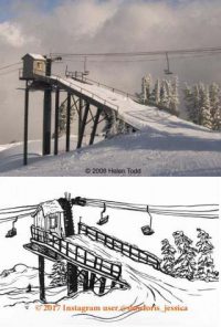 There is a ski lift chair being used as a bench on our back patio, and, in our guest bathroom, there’s a photo of that chair when it was part of Chair #1 at Mt. Baker. It’s a fun piece of history and nostalgia. I wrote about the