Last weekend, we put a coat of white, reflective paint on the flat roofs on the church property. I set up a GoPro in the corner of the roof on a tripod because I can’t even do manual labor without geeking it up.
By the way, if you want to see more stuff like this and photos from the work days that I organize at church, you can friend the church on Facebook. In addition to doing the property maintenance, I’m also the self-appointed social networking guy so I’d love to see our numbers go up!
As part of our Easter Sunday service, I did a bunch of recording for preservice music, postservice music and various parts of the service. Unfortunately some of the audio got a bit goofed up because the levels were set a bit too high, but it came out good enough to post on the church’s YouTube site. If you just want to hear some incredible organ, skip to minute 39.
Tim and I usually use our GoPro’s as part of the recording. We call one of them “Dave Cam” since it sits behind our incredible organist, Dave. This time I set the second one up in the balcony and set it to take a photo every two seconds. I used that timelapse as filler for the main video linked above, but the raw timelapse itself is pretty fun to watch. It starts at people are filing in before the service and ends as people are cleaning up after the service.
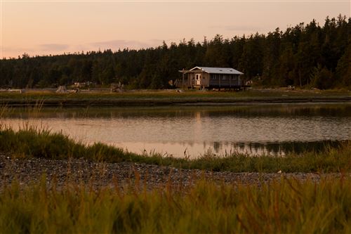
Tyla and I decided to take one last vacation before our son arrives in June. After going through a lot of options, we settled on Rosario Resort and Spa on Orcas Island. Orcas Island is part of the San Juan Islands and it’s about 100 miles away including a 17 mile, one hour ferry ride.
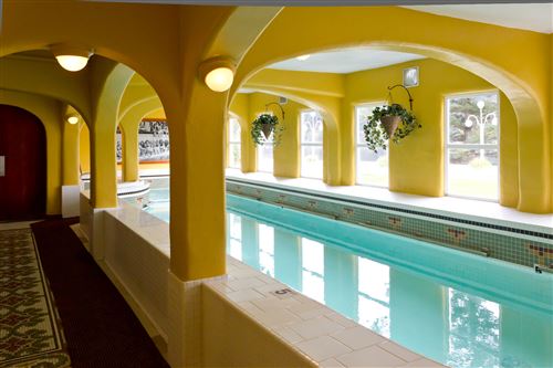
The resort was beautiful. The main building is the former home of Robert Moran. He moved to Seattle from New York in 1875 at the age of 18 with a dime in his pocket. From that point, he built up a fortune as a shipbuilder and also became the mayor of Seattle. The great fire of Seattle happened while he was mayor, but he still got reelected. His company then got a bunch of the contracts for rebuilding Seattle which helped increase his fortune. (How convenient…) He owned a big portion of the most scenic parts of the island and donated about 5000 acres of land to the state for Moran State Park where we camped back in 2009. The mansion now houses a museum, restaurant and spa (complete with original indoor pool.)
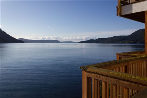
The resort and the entire island were pretty empty since it wasn’t peak season, but that also meant that the prices were low and we didn’t have to fight for parking or dinner reservations. We used our time to explore the island, examine tide pools, swim, and do lots of reading. Our room had a balcony that hung out over the water. It was so nice to hear the waves lapping on the shore!
We ate a simple breakfast in our room each morning and then headed out each day for lunch and dinner. Here’s a summary of the places we ate along with our reviews:
Madrona Bar and Grill This restaurant/bar sits in a beautiful location right on the waterfront. We got a seat right by the window and had some delicious food. Tyla had the salmon fettucine and loved that it wasn’t just the standard dish but instead had a nice mustard sauce. I had the fish and chips and enjoyed a big mug of Mac & Jacks. We’d love to go back!
Rose’s Bakery & Café This café was full of great employees. It seemed like the type of place that Lauren and Andy might start some day. My sandwich and Tyla’s soup were delicious but a little pricey. We finished it off with some warmed up cobbler and incredible buttermilk ice cream.
Lower Tavern This bar walks the line between local dive bar and family restaurant. I think it could go either way depending on the crowd. On our night it was full of locals enjoying themselves but not being very rowdy. They say they have the best burgers on the island. Ours were good, not the best we’ve ever had but they probably are the best on the island. The meat was average but the toppings were great.
Enzo’s Italian Café This café is quite a bit smaller than Rose’s but it includes crepe, espresso and gelato stands in addition to the sandwiches and desserts. Tyla loved her ham and cheese Panini and I had one of the best slices of chicken pizza that I’ve ever had! After walking around town for a bit, we came back and got a slice of cherry pound cake.
Agave Restaurant and Tequila Bar Our final stop was the Agave restaurant. Being the off season, we were the only people in the entire restaurant for most of our meal! That’s ok though because Tyla got to sit right next to the fire. The food was ok but not spectacular. There are a few other Mexican restaurants on the island so I’d probably try one of those next time.
My favorite stop on the food tour was Madrona and I think Tyla’s was Enzo’s. Those would be two great stops for lunch and dinner on your day trip to Orcas Island.
Photos from our trip can be found in the photo gallery but I’ve also included a few of my favorites below.
Using the GoPro, I also made a timelapse from our balcony. It’s not terribly exciting but you can watch the clouds move and see the tide go in and out.
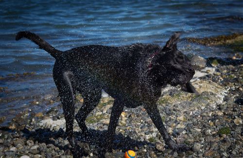
We headed out for a last minute camping trip to La Conner, WA with Tyla’s family a couple weekends ago. We’ve been to that campground once before, but the last time it was cold and rainy the whole time. This was a quick trip, but the weather was good and Oskar had fun playing in the water. I, of course, had fun playing with the camera. I finally succeeded in getting shots of Oskar shaking off where the sun was at the right angle and he wasn’t blurry. A shutter speed of 1/1000th is just barely enough to freeze most of him. I also attempted a timelapse of the sunset. That’s fairly difficult since the exposure changes so rapidly but you have to leave it fixed or else the sky never gets darker. This one is pretty short and not stellar, but I embedded the YouTube video anyway. More photos are available in the photo gallery.
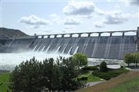
It inevitably rains in the Puget Sound area over Memorial Day, so this year we decided to head east of the mountains. For those of you unfamiliar with Washington geography, the Cascade Mountains run down the state and create two very different environments. The west side is dominated by the ocean weather so it’s very mild year round with lots of rain. The east side of the mountains is a certified desert with extreme temperatures. You’re almost guaranteed to get sunshine. So with that knowledge in hand, we looked into a trip to the Grand Coulee Dam.
Unfortunately Tyla and I came up with this plan with her family very late and only had a couple camp sites to pick from. I picked a spot at Sun Banks Resort mostly at random. You know how you have that one horribly wet camping trip that will forever make you say “well it least this trip isn’t as wet as THAT one”? I now have a similar comparison for loud and tiny campsites. Our site was maybe twice as big as their camper. Our fire pit was about 8 feet from our (thankfully friendly) neighbors. And the rest of the campground was populated by college kids drinking and partying nearly around the clock with brief breaks for vomiting. I’ve never seen that many beer bottles laying around a campground. The only good thing is that we were on the end of the campground in a group of sites that were a little bit separated from the main party and we bordered the lake. That being said, I felt pretty dumb for picking the site but it could have been worse.
On Saturday we checked out the dam and the Visitors Center there. We found a spot for Oskar to swim and basked in the sunshine. We capped off the day with a short drive back to the dam to watch the laser light show. You should probably see it once but be warned that it’s 40+ minutes long. We were all fighting sleep by the end.
We started off Sunday with a trip back to the dam to take a tour. There are a lot of restrictions post-9/11, but we went down into the third powerplant and they drove us across the top of the dam. I’ll probably make a second post full of the facts we learned on that trip. It’s an incredible piece of construction!
After lunch on Saturday, we headed out on a hike that I picked off the web. At 4 miles and 600 feet of elevation gain, it seemed pretty simple once you got past the “0.15 miles of rock scramble.” Once I saw the hike, I should have turned us around. That first bit was pretty treacherous, often requiring getting down on all fours to make it up the sandy and rocky “path.” Nancy and Logan made it up the first part and then turned around. The rest of us continued on but turned around before making it to the top as we were running out of water and energy. Plus we knew that going down would be even harder than coming up. Unfortunately that was very true.
We had barely started back down the trail when Tyla took a tumble. The squeamish among you should skip this paragraph. She caught her thumb nail on a rock and bent it back about halfway down the nail ripping the nail off the nail bed. Blood ensued as I whipped out my first aid kit and tried to remember the class Tim and I took. I got her bandaged up but then we had to get all the way down the trail and she had lost use of one hand. Thankfully we made it down without any more serious injuries.
Bear Grylls says that a very bad day is a series of small mistakes that you ignore. I was tired of ignoring small mistakes so I decided to put an end to it by taking Tyla to the doctor. If we were at home we might have tried to clean it up ourselves, but we didn’t have many supplies. The only doctor in the small town that was open on Sunday was the ER so that’s where we ended up. They cleaned it out well for her, gave her tips on keeping the pain away, and were very nice in the whole process. Thankfully there was no line so we got through pretty quickly. After hearing what they had to say about it, we probably could have skipped that trip, but I was happy to have finally erred on the side of caution for once and we both felt better knowing that nothing more serious had happened.
So I have to give a huge thanks to the Brandt family for hauling their camper halfway across the state, feeding us, and putting up with my bad choices! If I ever get to pick another campground, I’ll try to find a bigger/quieter one and you can bet that the next hike will be something we can all do without major risk of injury. Thank you all for being so nice about the whole weekend!
This post is already getting pretty long so I’ll save the pictures for another day. However, on the way out there I did mount the Kodak Zx3 to the windshield and make a timelapse video. I wanted to show everyone who quickly the weather and environment can change! In an hour or two, I can drive from wet, cool weather, over a mountain pass through snow and down into a desert complete with tumbleweed!
I recently picked up a Panavise 809 Camera Window Suction Cup camera mount. It’s for my little car timelapse video hobby, but it dawned on me that it might also work for the motorcycle. I was able to stick it onto the gas tank and get a pretty good view with my Kodak Playsport Zx3. There is a significant amount of vibration, but by bringing the footage into Adobe Premiere I was able to use some filters to remove some of the vibration effect.
I posted the video on YouTube and it’s also embedded below. This video was taken on NF-56. It’s the forestry road that runs between exits 47 and 52 on I-90 up in Snoqualmie Pass. At that point the highway splits and this road runs down the valley in the middle. It’s a great ride! After I reached the end I took a quick zip up to Alpental and then got back on I-90.
Look right around the 5:00 mark and you’ll see a guy come streaking down the hill dressed in full leathers riding a longboard (also shown in the image above.) At 5:15 I passed the second guy followed by one of their friends in a car. It’s completely illegal but it looked like a lot of fun. I’m nowhere near crazy enough to try that though.
Yesterday I posted a timelapse video where the main feature was the GPS points on the topo map. When we drove back from Potholes a few weeks ago, I focused more on the images. I taped a USB webcam to the rear view mirror and had it connected to the laptop which was running an app to capture an image every two seconds. That worked great except that there was a problem with the inverter and the laptop battery died before we even made it back over the pass.
I took the images that we were able to snag, combined them with the GPS data and created another timelapse video. It’s all done with a custom C# program so if you geeks out there have any questions, let me know. Basically it’s a WinForms app with a web browser that loads the Bing maps and then I use Win32API calls to capture an image of the app. I have another app that combines all the image files into a WMV file.
The next thing I want to try is using the little HD video camera to record the images/video and see how that works. I have a suction cup camera mount that should make it easier to mount in the car and using the video camera means that I won’t need to have the laptop running. I plan to give it another try when we drive out to the coast in a couple weeks.
The video is embedded below, but again, it works best when you view in full screen HD quality. The GPS wasn’t able to get a lock on the signal for a while so it starts out with just images and then the location data kicks in. I wasn’t intentionally trying to keep our camping spot a secret since you could just watch the images and figure out where we were.
I’ve been playing around with a lot of time lapse ideas lately. I took some pictures for part of the return trip from Potholes which you’ll see soon, but on the hike up to Muir, I distracted myself by thinking how I could combine all the various data I had collected into one display.
In the backpack, the GPS was taking a recording every few seconds. I was also snapping photos every once in a while. To combine the two, I wrote an app to plot out our current location on top of a topo map and show a photo that was taken at that time (if one exists.) With the GPS data, I was also able to show our rate of ascent, the current elevation, the current time, and the latitude and longitude.
I combined that all into one application, wrote each update out to a new image file and then combined the image files into a movie file. It’s embedded below or you can find it on YouTube. It’s best when viewed in HD in full screen mode.
I try to avoid videos with no text since it doesn’t translate well when I publish the books, but this timelapse from the top of Whistler mountain is incredible.

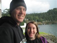 Tyla and I decided to take one last vacation before our son arrives in June. After going through a lot of options, we settled on Rosario Resort and Spa on Orcas Island. Orcas Island is part of the San Juan Islands and it’s about 100 miles away including a 17 mile, one hour ferry ride.
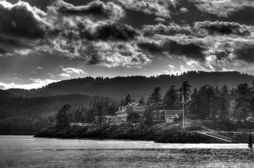
 It inevitably rains in the Puget Sound area over Memorial Day, so this year we decided to head east of the mountains. For those of you unfamiliar with Washington geography, the Cascade Mountains run down the state and create two very different environments. The west side is dominated by the ocean weather so it’s very mild year round with lots of rain. The east side of the mountains is a certified desert with extreme temperatures. You’re almost guaranteed to get sunshine. So with that knowledge in hand, we looked into a trip to the Grand Coulee Dam.
 I recently picked up a