
One of the first things I purchased for my bike was a new dolly. The old platform dolly was a bit unwieldy for this shiny (and heavier) new bike. I saw the Park-N-Move at the Seattle motorcycle show and thought it would be a good fit for this bike. It’s a small, but very sturdy, cast iron dolly that sits under the center stand. I made a little video demo of how it works.
Italian Style Chicken Breasts
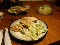 Hopefully Mom doesn’t mind me posting her top secret family recipe. This is one of our family favorites. Two thumbs up!
On a side note, I realized that it’s kind of silly to have a ranking system for recipes that make it to the blog. Why would I post a bad recipe? I’m only going to be sharing the ones that we really liked. Also, I know there have been a lot of food posts recently, but that’s because we had a backlog of things to write about. This is the last of the backlog so I expect them to slow down going forward.
Italian Style Chicken Breasts
- 2 whole chicken breasts
- 1/2 cup fine dry bread crumbs
- 1/2 cup parmesan cheese
- 2 eggs, well beaten
- 1/2 cup margarine
- 1/2 lb sliced fresh mushrooms
- 2/3 cup white wine (Mom recommends white zinfandel)
- 1 cup mozzarella cheese
Mix bread crumbs and parmesan on a plate. Beat eggs on a plate or flat bowl. Dip chicken breasts in egg then in bread crumbs. Make sure it is coated well.
Melt margarine in skillet over medium heat. Add chicken and brown on both sides. Remove chicken to a shallow baking dish (9×9 pan.) Add mushrooms to skillet and cook until almost tender, stirring frequently. Mix in wine. Pour mixture over chicken.
Cover with foil and bake at 350 for 20 minutes. Uncover and sprinkle mozzarella cheese over chicken. Return to oven uncovered and bake 10 more minutes or until chicken is no longer pink.
I made this for Tyla on Valentine’s Day and served it with a Caesar salad and baked potato. Baked potatoes taste excellent when you use cover them with the extra sauce.
Also, Two Vines Riesling is delicious! I bought it a few months ago and forgot about it. After that, Tyla was telling me how great this wine was. On Valentine’s Day, I pulled out a bottle of wine and discovered it was the one she had been talking about. Jackpot! Err… I mean… I planned it that way because I knew how much she loved it.
Chicken Stuffing Divan
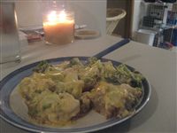 Tyla and I found this recipe in the Campbell’s Casseroles and One-Dish Meals book. It was so good we made it again the next week. Our only change was using chicken instead of the recommended turkey. It would taste just as good with turkey though. The deliciousness to effort ratio for this one is off the charts!
Chicken Stuffing Divan
- 4 cups Pepperidge Farm Herb Seasons Stuffing
- 1 1/4 cups water
- 4 tablespoons butter
- 1 package (10 ounces) frozen broccoli cuts, cooked and drained
- 2 cups cubed cooked chicken
- 1 can (10 3/4 ounces) Campbell’s Condensed Cream of Celery Soup
- 1/2 cup milk
- 1 cup shredded Cheddar cheese
- Prepare the stuffing using the water and butter according to the package directions.
- Spoon the stuffing into an 11×8-inch shallow baking dish. Arrange the broccoli and chicken over the stuffing mixture.
- Stir the soup, milk and 1/2 cup of the cheese in a small bowl. Pour over the turkey mixture. Sprinkle with the remaining cheese.
- Bake at 350F for 30 minutes or until hot.
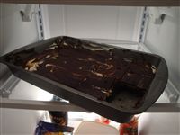
That photo is horrible. We didn’t think to take a picture until we were into the second night of leftovers. Just make it. It’s fantastic!
First Weekend
I promise the motorcycle posts will slow down once the rain returns, but the sunny days and shiny new bike in my garage have been dominating most of my thoughts lately. This past weekend I put a little over 250 miles on the bike with various rides. Tyla and I had our first adventure on the bike when we headed into Ballard to see Matt and Laura and then ran up to Everett and back down Highway 9.
I’m still in love with the bike, and I’m itching to get through the break-in period. For the first 500 miles I have to keep it under 4000 rpm, and then I can take it up to 6000rpm until I hit 1000 miles. After that I’m free to run it as hard as I want (redline around 11,000!)
I have a list on my computer of things I want to add to the bike and it is growing longer by the day. Here’s what I have so far in approximate order of priority from greatest to least:
- Saddlebag surface shields (already ordered)
- Tank surface shield
- Center stand dolly
- Handlebar risers
- Foot peg lowering kit
- Helmet lock kit
- Two Brother’s slip on exhaust
- Maintenance videos
I’m doing pretty well at holding off on the purchases as the priorities of various items rise and fall in these first days.
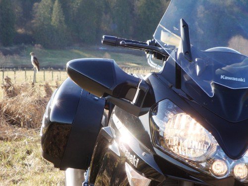
I did get some new photos, but only one that I really want to share. I pulled over to the side of the road to shoot some photos, and when I lined up the shot below, I noticed a hawk on the fence post behind my bike! Unfortunately I only got a couple shots before he flew off, but this one turned out pretty well.
KIPASS
 My bike is full of geeky engineering and technology. It’s going to take me a while to discover and understand a lot of it, but one immediately apparent gadget is the KIPASS (Kawasaki Intelligent Proximity Activation Start System.) It’s similar to the Prius key if you’ve seen that.
The basic idea is that the key always remains in the bike. There is a key fob that must be within 5 feet of the bike to turn the key or even take it out. I keep the fob in my coat. As soon as I walk up to the bike, I can start it without fumbling around for my keys. If the bike is turned on and leaves the radius of the key fob, the engine will shut off after about 10 seconds.
The system doesn’t really protect against theft because most motorcycle theft involves four guys picking up a bike and throwing it in the back of a truck. I’m also a bit concerned about locking myself out of the house since there is nothing stopping me from leaving with my house keys. Maybe I can get my house to unlock when I’m within five feet of the door!
Economic Stimulus Package
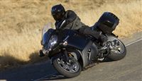
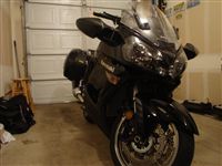 I’m happy to announce that yesterday I enacted my own economic stimulus package with the purchase of a brand new motorcycle. It’s a 2009 Kawasaki Concours 14 ABS. The bike is classified as a “supersport touring” motorcycle. It’s based on Kawasaki’s top of the line ZX-14 sport bike but it has a few refinements to make it suitable for very long rides. The seating position is more comfortable, the windshield is bigger, it has a shaft drive instead of a chain, and there are bags on it. It has a 1352cc engine which puts out roughly 140hp. For those of you keeping track, that’s about 85% of the power that my Subaru has and it was less than a quarter of what my car does. Yikes! Needless to say, this thing is crazy fast. My Mustang ran the quarter mile in 13.9 seconds. This bike will do it in about 10.5 seconds. It provides all that speed and power while pampering the rider with smoothness, gadgets galore, and comfort. I compare it to a Bentley. It’s a ridiculous amount of power and luxury that no one really needs, but we all want it.
I got a few accessories with it. I ordered a larger windscreen since I’m a bit too tall for this one to work effectively (it raises and lowers electronically!) I also ordered a rear trunk for even more storage. I’m hoping that Tyla and I can take some weekend trips and have enough room to be comfortable. Each of the three bags will fit a full helmet with room to spare. This is a major upgrade from my last bike.
Thanks to Greg at Waldron Kawasaki for making this deal happen. They are fantastic people, and they have been doing maintenance on my Vulcan since I arrived in Washington. I chatted with a few of the dealers in the area, but they ended up matching my best offer and I was very happy to give them my business. Their service department is absolutely wonderful. It’s great to have a mechanic I can trust.
I picked it up yesterday after dark so I don’t have any good photos, but I have added some photos from my garage. The Vulcan was part of the deal so that is long gone. I have fond memories, but it’s hard to miss it much when I have this to ride instead. The first few trips will be part of the break in period but I look forward to really winding this up and letting it run. This will provide a lot of fun in the months and years to come! Are you ready to ride Tyla?
One Million Vertical Feet
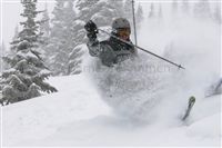 Since the 2005-2006 ski season, I have been tracking how many vertical feet I have skied with a Suunto watch. I skied a handful of times before that season, but we’ll just stick to that year since it’s when I really started skiing regularly.
Since that time, I have skied over one million vertical feet! I crossed the milestone last Tuesday during racing at Alpental. To put that into perspective, that’s like going 190 miles up in the air and skiing down. That’s just a little bit lower than the space station! Given the average ski slope (as calculated by my GPS data), that means I’ve traveled over 1500 miles on skis. That’s longer than the distance from Seattle to Minneapolis!
Some other stats about the first million vertical:
- It took 843 ski runs over 59 days to accomplish this.
- The biggest single day ever was 62,000 on March 8 of last year for the American Cancer Society fundraiser.
- At just about every resort I visited, the average ski run was between 900 and 1200 feet high.
- I visited 18 different ski areas.
Here’s to the next million!
PS. That lovely photo is one of the rejects from our photo shoot last winter. Bernard asked us to sign waivers so he could sell the photos and I’m betting that’s one that got picked. Haha I hope it gets used in a magazine sometime.
Mint Brownies
 If you’ve ever been to a pot luck meal at church, you’re probably very familiar with mint brownies, at least that’s what I associate them with. These are the brownies with a green mint frosting covered in a harder chocolate frosting.
We put our own twist on the recipe and it turned out fantastically.
Mint Brownies
- Boxed brownies
- 2 eggs (use 2 instead of 3 to make them a bit more dense)
Frosting
- 2 cups powdered sugar
- 2 tablespoons milk
- 1/4 teaspoon peppermint extract
- 6 tablespoons butter or margarine, softened
Chocolate Glaze
- 3 squares unsweetened chocolate
- 1 square semisweet chocolate
- 4 tablespoons butter
- 2 teaspoons dark corn syrup
- Bake brownies according to directions on box. Allow to cool.
- Prepare mint butter-cream frosting by mixing at low speed: powdered sugar, milk, peppermint extract and 6 Tbs. butter until smooth. Stir in enough green food coloring to tint a pretty green. Evenly spread frosting over cooled brownies. Refrigerate while preparing Chocolate Glaze.
- Chocolate Glaze: In a heavy 2-quart saucepan over low heat, heat glaze ingredients until chocolate melts and mixture is smooth, stirring frequently. Remove saucepan from heat; stir frequently until glaze cools slightly. Carefully spread glaze over frosting to completely cover top. Refrigerate until glaze is set, about 1 hour.
The original recipe had instructions for making the brownies from scratch, but we used boxed brownies and it worked just fine. We also skipped the aesthetics of the green food coloring. I also jumped the gun on the chocolate glaze and didn’t let it cool enough. It melted into the peppermint frosting and gave a swirl effect as I spread it around.
Short answer: delicious. We give this one a 3/3.
Nacho Chicken and Rice Wraps
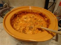 Over the last half year, Tyla and I have been trying all kinds of new recipes. Some have bombed. Some are on permanent rotation. It seemed like good blog content, so I’m introducing a new post category: Recipes. So without further adieu, I present Nacho Chicken & Rice Wraps. (On a side note, wouldn’t it be great if “adieu” contained an “o” too?” The shortest word that contains all five vowels is “aeirious.” Now you know. Oops, I think this qualifies as more adieu. Oh wait, it’s “further ado”, not “further adieu.” Adieu means goodbye which makes no sense, but ado means fuss, trouble or excitement. Back to the food!)
Nacho Chicken & Rice Wraps
- 1 can (10 3/4 ounces) Campbell’s Condensed Cheddar Cheese Soup
- 1 cup chunky salsa or picante sauce
- 1/2 cup water
- 3/4 cup uncooked regular long-grain white rice
- 1 pound skinless, boneless chicken breasts, cut into cubes
- 1 small can of mushrooms
- 5 flour tortillas (10-inch)
- Stir the soup, salsa, water, rice and chicken in a 2 quart slow cooker.
- Cover and cook on LOW for 7-8 hours (or high for 4-5 hours) or until the chicken is cooked through.
From: Campbell’s Slow Cooker Recipes Cookbook (modified by us)
The original recipe is twice this, but it said it made 10 servings. We cut it in half and got 4 servings out of it. I find that my servings are always bigger than the cookbooks suggest. I’m a big boy. We also added the mushrooms because I had them already and Tyla loves them.
I had low expectations for this, but it ended up being quite good and I look forward to making it again. When we make recipes from the cookbook, we label them with two pluses for fantastic, one for good, and a minus symbol for things we wouldn’t make again. For blog purposes, we’ll use a scale of 1 to 3 where 3 is the best. This one gets 2/3. Tyla said she’d add sour cream next time and maybe use a little less salsa. I put green tabasco on mine and loved it the way it was.
Oh, and that picture doesn’t do this justice. We’ve already discovered that we don’t know how to photograph food. Get used to it. Also, the observant among you may notice that my slow cooker is a different color in various photos. I bought one that has three bowls (2, 4 and 6 quarts.) Each one is a different color so it will vary depending on how much food we’re making.
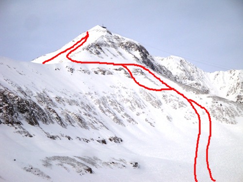
More Big Sky
There were a few more things about Big Sky that I want to share with you. First of all, I mentioned some great lines that we took down from Lone Peak. This photo shows a couple of the runs down through the Gullies and hints at one down the side of the mountain. We had many more runs down, but I don’t have a good picture to show them.
I also made a panoramic photo from the top of the peak. It’s not quite 360 degrees, but it’s pretty close. We could see all the way down to the Grand Tetons! Click on the image for the full file (8MB) or view the nicer HDView version.

And finally, I took a bit of video on the snowmobile tour through Yellowstone. Riding one handed is a bit difficult so please pardon the shaky video. The first portion of the video is just a normal part of the ride. The last 20 seconds or so show us passing a herd of bison. While this looks very close, we actually came much closer to another herd, but I wasn’t able to get video because I was too busy trying not to die.