
 Saturday was our one year anniversary. 365 days ago, Tyla and I had our first date, and for some reason, she has put up with me for a whole year. To celebrate, we drove down to Mowich Lake.
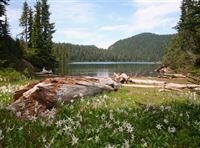
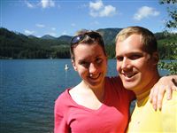
Mowich Lake is located in the northwest corner of the park, a part I have never been to. It is the deepest and largest lake in the park. You access the lake via a 17 mile long dirt road. Before you go, make sure you check the website to see if the road is open. It just opened last Thursday so it takes them a while to get it ready for traffic. I think the next time we go back, we’ll take an SUV or a truck. The Subie survived, but I felt a bit bad about bouncing it along those washboard roads. Thankfully, the dirt road keeps a lot of people away and there were not a ton of people around. Don’t worry about trying to find a spot in the tiny lot, just park along the road and make your way down to the trail that circles the lake.
We found a very secluded spot right at the water’s edge to have a private picnic lunch. I was tempted to go back to the car for my swimsuit, but after wading in up to my knees, I realized that swimming in a glacier fed lake wouldn’t last too long. It was frigid! By the way, this was the second weekend in a row that I have played in the snow on dormant volcanoes. Have I mentioned I love the Pacific Northwest?
After lunch, we hiked to the south end of the lake where most of the crowd was. There are about 30 camping sites, but it’s really just a big rock field where you can pitch a tent. If you were doing a lot of hiking in the area, it might be worth it, but otherwise I think we’ll skip that campground.
Normally you’d see majestic Mt. Rainier just over the hills but there were too many clouds to give us a good view. You can check out the photos in the photo gallery or view the panoramic shot by clicking the image below (~17MB.)
We finished the day with dinner at Matts’ Rotisserie and Oyster Lounge in Redmond Town Center. (Minus eleventy billion points for auto playing background music when you open their site.)
Thanks to Tyla for yet another wonderful adventure. The last year has been full of them and I can’t wait to see what lies ahead!


 I’ve driven the road from Bellingham to Mt. Baker a few times, but it has always been in the winter with skis on top of my car. On Saturday, I did it on the motorcycle.
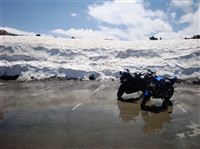
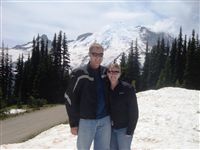 On Sunday, I hopped back on the bike for another ride. I recovered surprisingly quickly from the 440 miles on Friday. This ride took Tyla and I down to Mt. Rainier. It’s a very nice ride covering mostly two lane roads and then a very nice windy road up to Sunrise lookout. There was heavy traffic, but not as much as I was expecting considering the holiday. Plus, traffic always seems lighter on the motorcycle since it is much easier to pass.
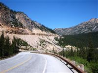 Not only did I survive the ride on Friday, but I thoroughly enjoyed it! I took almost the exact route that I talked about in the
 Tim, Chelsea, Andy, Stephanie, Nick (an intern at Tim’s company), Tyla and I spent the weekend about 15 miles east of the summit of Snoqualmie Pass at Lake Easton State Park. We all convened at campsite 109 after work on Friday and crammed five tents onto the tent pad. The rest of the weekend was filled with cornhole, beverages, campfires, delicious food, and hanging out down by the water. The lake was beautiful, but the campground was very loud. I-90 was only a few hundred yards away. I guess when you try to cram train tracks, a lake, a campground and an interstate into a mountain pass, there’s not a lot of leftover room. It was great for a weekend trip considering how close to home it is(60 miles from my house.) On Sunday morning, we packed up and visited Mountain High Hamburgers on the other side of the interstate. It’s a Scherschel family favorite and made a nice end to the weekend.
 On our trip to Indiana, we stopped at Granite City for dinner. It’s one of Tyla’s favorites and I finally got to try the Idaho Nachos that I heard so much about. Last weekend we decided to try and make them for ourselves. I think they actually tasted better than the ones from the restaurant!
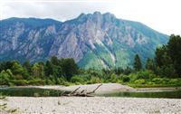 If you spend much time in this area, it doesn’t take long to recognize Mt. Si. Just east of North Bend, this chunk of rock is about 4200 feet above sea level. The hike to the top is 4 miles long and gains about 3300 feet. It’s one of the most popular day hikes in the area, but for some reason, I’ve never done it. I can see it when I drive out of my house and it bugs me every day that I haven’t been to the top.
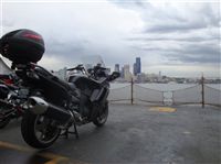 If you live in the Seattle area, it’s probably not too hard to figure out that I love my motorcycle. I’ve been riding it every time I get the chance, and thanks to our incredible weather, I’ve had a lot of chances. Numbers always help to draw comparisons though. I had my first motorcycle for four years and I put 10,000 miles on it. The brainiacs among you will realize that I averaged 2500 miles/year. I bought this new bike in mid-Feburary. The odometer already reads 2700 miles and we’re not even halfway through the calendar year!